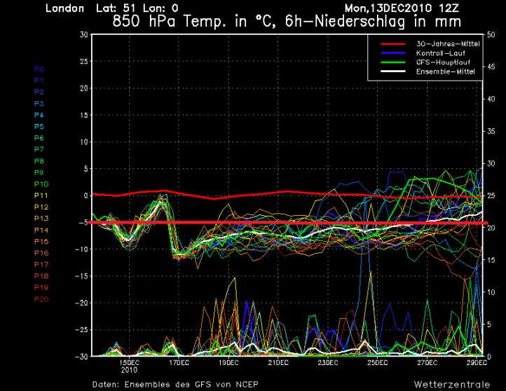
Todays computer models are out and boy has there been a big switch around. To give you an idea of just how quickly these models can turn around, I’ve updated yesterdays and todays Ensemble charts so you can compare them and see for yourself. I’ve drawn a thick red line straight across the chart (the bottom red line) to show where the -5c line is. For snowfall, ideally we want as many of the lines below that line.
Yesterdays
Today
You can see for yourself just how much of a difference there is between the two charts, with todays forecast Ensembles going for colder conditions to prevail until Christmas. With the Ensembles chopping and changing so much in such a short period of time, it’s very hard to have any confidence within them, however considering other, separate forecast models are also forecasting the cold weather to return from Thursday onwards, there is growing confidence.
The models show something called the Polar Vortex pushing South across Western Europe and over the UK, the Polar Vortex usually sits across the Arctic but a building area of High Pressure has displaced it, so it’s looking increasingly likely that we’ll see a return to the very cold conditions, and some areas will see further significant snowfall as we move through the weekend and next week.


Wow oh wow!
The polar vortex thing sounds interesting indeed! This winter has just been epic for UK standards. I haven’t had much snow fall myself (just a dusting) but my word, alot of places have been amazingly cold and snowy. I can’t wait til the coming days.
Oh, Daniel, great blog my friend! Bookmarked and look forward to your next post. All the best, and have an amazing Christmas!! 🙂
Hi Jamie. There’s definitely an interesting couple of weeks ahead of us and I’m almost certain some areas will see significant snowfall again. The focus may be for more Western areas initially though, so everyone getting in on the fun.
All the best, and Merry Christmas 🙂
Hey Daniel i am no expert but i did notice last year the AO index went very low i see its very for the next 14 days its even lower then it has been in the recent cold snap.
Does this always mean cold weather for UK etc and do you think east ireland will get any snow this week or will it be more west and north coasts of ireland
your website is by far the best one iv seen seen
regards john
Hi John, thanks for the compliments, I appreciate that. The AO is forecast to drop very negative once again, in-fact it could drop as low as it did last winter for a time so very close to breaking the records again.
A negative AO is indicative of High Pressure across the Arctic, whilst this does help send cold weather our way, there are many other factors involved, but with a negative AO then the chances of prolonged colder air reaching our shores is significantly increased.
I think to start off with, winds will be more North-North-West so I think North-Western Ireland would definitely have the highest chance of seeing those snow showers coming in off of the sea, you’d be more sheltered though as we move towards the weekend, disturbances in the flow are expected to develop so your chances of seeing snow will increase as we move into the weekend.
Kind regards